The marine environment of the Auckland Islands in the New Zealand Subantarctic Islands group is home to a diverse range of species. Use this interactive image to learn about this diverse ecosystem and some of the methods scientists are using to learn more about these unique islands.
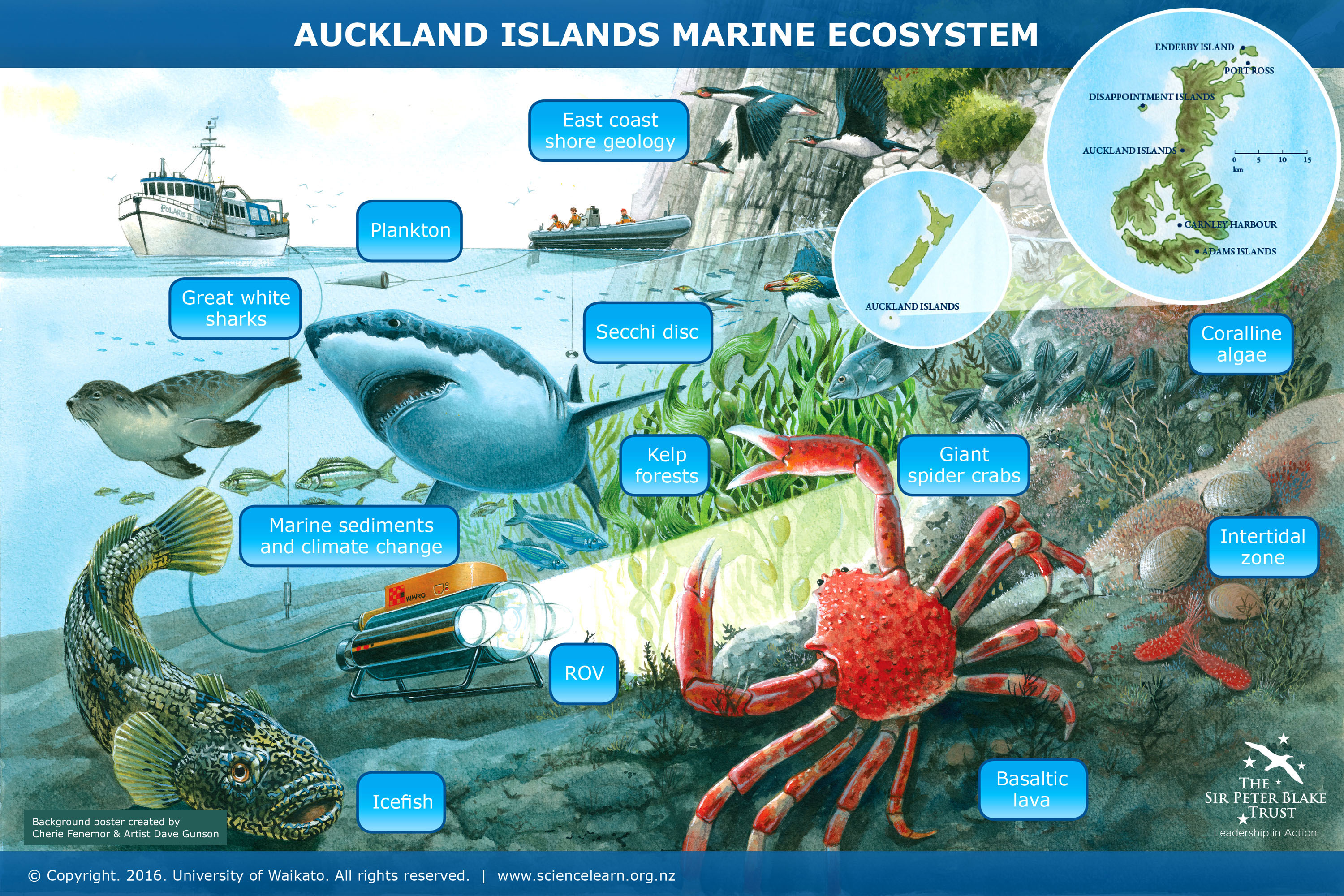
The marine environment of the Auckland Islands in the New Zealand Subantarctic Islands group is home to a diverse range of species.
The Auckland Islands marine environment is unique in that it is both a marine mammal sanctuary and a marine reserve. The marine mammal sanctuary was established in 1993 and provides 12 nautical miles of offshore protection for sea lions and southern right whales. The halt in commercial fishing operations that came from the development of the marine mammal sanctuary not only protects the mammals but also prevents commercial harvest of all species within the sanctuary. In 2003, in recognition of the high levels of endemic marine plant and animal life, the area also became a marine reserve, protecting all species.
In this interactive, learn about this diverse ecosystem and some of the methods scientists are using to learn more about these unique islands. To use this interactive, move your mouse or finger over any of the labelled boxes and click to obtain more information.
This interactive was adapted from resources produced by Cherie Fenemor from Freyberg High School who joined the Young Blake Expedition to the Subantarctic as the Sir Peter Blake Trust Educator in February 2016. The original artwork is by Dave Gunson.
Transcript
Great white sharks
Great white sharks have been tracked to these waters, although it is unclear whether the Auckland Islands have their own population of these sharks or whether they just visit the Subantarctic from Stewart Island. Evidence has been seen of scarring on sea lions, suggesting that they’re preyed upon by the great whites.
How would a scientist go about determining the migratory patterns of great white sharks found around the Auckland Islands?
Image acknowledgement: Michael Bogner, licensed from 123RF Ltd
Plankton
Plankton are drifters of the sea at the mercy of ocean currents. Plankton play many important roles as they form the basis of the marine food web, produce significant quantities of oxygen and also sequester large amounts of carbon. At the Auckland Islands, zooplankton have been collected using a drop net to provide baseline data about the presence of different plankton species. Looking at changes over time could help scientists understand the impacts of climate change on plankton communities.
Why might scientists want to understand the impacts of climate change on plankton communities?
Image acknowledgement: National Institute of Water and Atmospheric Research (NIWA)
Secchi disc
A Secchi disc (named after its creator) is a tool used to measure water clarity. It is lowered into the water while attached to a tape measure or pole with marked measurements. As the disc is lowered from a vessel, the depth at which it can no longer be seen is called the Secchi depth – a measure of water clarity. This can provide an estimation of the amount of phytoplankton at the sea surface. Living at the surface means phytoplankton are vulnerable to changes in sea surface temperature as a result of global climate change. Declines in phytoplankton could cause widespread change in the marine ecosystem as phytoplankton are primary producers – the basis of many marine food webs.
How would scientists estimate phytoplankton populations in relation to Secchi disc measurements?
Join a global citizen science project using Secchi discs to study marine phytoplankton concentrations.
Image acknowledgement: Public domain
East coast shore geology
The steep, glacially carved, shores of the east coast inlets are formed from layers of basaltic lava. In many places columnar basalt can be observed. These columns were formed due to contraction when cooling. After the eruption, the top of the lava flow was cooler than the lava beneath it, so it cooled first, fracturing as it contracted. As the lava continued to cool, the fracturing spread downwards, forming long, geometric columns.
The image shows McLennan Inlet – a classic deep, steep-sided U-shaped inlet formed from a glacier eroding the basalt.
How do scientists know that these geological features have been altered as a result of ancient glaciers?
Image acknowledgement: Cherie Fenemor/Sir Peter Blake Trust
Marine sediments and climate change
Marine sediment cores from the glacially carved fiords of the Auckland Islands are analysed in conjunction with lake and peat cores. This analysis includes radiocarbon dating and the study of the carbon and nitrogen isotopes they contain. The analysis will help to reconstruct changes in the southern hemisphere westerly winds, which play an important role in New Zealand’s climate and the carbon dioxide exchange between the Southern Ocean and the atmosphere. Understanding past climate changes will help scientists to understand current and future climate change.
Learn more about other research by GNS Science using sediment cores to understand climate change, or study our carbon cycle interactive.
Image acknowledgement: Hannes Grobe/Creative Commons 3.0
Kelp forests
Kelp forests are highly productive areas in the subtidal zone. As with the intertidal zone, the subtidal zone of the Auckland Islands is missing many species found around mainland New Zealand. In particular, there are very few species of large brown algae, resulting in a sparse understorey beneath the giant kelp in deeper, sheltered areas of the islands. At the Auckland Islands, the kelp is grazed by a small endemic pāua – the Subantarctic or virgin white-foot pāua.
Why do you think the subtidal zone of the Auckland Islands is missing many kelp species found on mainland New Zealand?
Image acknowledgement: Fastily, licensed under GNU Free Documentation License and Creative Commons Attribution ShareAlike 3.0
Giant spider crabs
The giant spider crab (Jacquinotia edwardsii) can be found from the intertidal zone to 500 metres in depth, but at the Auckland Islands, they are most abundant between 20 and 40 metres. They are New Zealand’s largest crab, with males having a leg span of up to 1 metre. At the Auckland Islands, they can be found in densities of up to 10 crabs per square metre. Males forage on blue and ribbed mussels and probably other shellfish, whereas females are detritus feeders, and juveniles feed on drift algae.
Why might giant spider crabs have adapted so that females and males have different diets? Can you think of another animal where the males and females eat different diets?
Image acknowledgement: Jacob Anderson/Sir Peter Blake Trust
Coralline algae
Coralline algae have calcium carbonate (hard parts) in their cell walls making them vulnerable to ocean acidification. Even subtle shifts in acidity can hinder the formation of calcium carbonate and cause it to dissolve. The distribution, abundance and diversity of coralline algae will likely prove to be excellent indicators for changes in ocean chemistry due to their sensitivity to changes in pH.
Learn more about bryozoans, a marine creature that is also vulnerable to ocean acidification.
Image acknowledgement: Dr Rebecca McLeod/Sir Peter Blake Trust
Intertidal zone
The intertidal zone and related community at the Auckland Islands is considerably different from mainland New Zealand. In the eastern fiords, the tidal range is only 1 metre, and some components of the mainland intertidal community, such as large sea stars, are under-represented or missing. Interesting features of the community include very large limpets, chitons and mussels and a very diverse range of seaweeds. In exposed sites, the bull kelp Durvillaea antarctica dominates the shore. Species composition and changes over time in the intertidal zone can be measured using transects and quadrats.
Learn more about reef zones such as the intertidal zone.
Reef zones are, in essence, a scientific construct. Why do you think scientists group different marine habitats?
Image acknowledgement: Dr Rebecca McLeod
Icefish
The most abundant fish of the Auckland Islands are the icefish of the family Nototheniidae. This family is known for its adaptation to its Antarctic origin – having ‘anti-freeze proteins’ in their blood. These proteins ‘attach’ to the surface of ingested ice crystals, halting ice formation and allowing bodily fluids to stay fluid. The icefish at the Auckland Islands are non-Antarctic members of the genus Notothenia – N. angustata and N. microlepidota. These fish have extremely low anti-freeze levels in their blood. However, as the anti-freeze proteins are present, an Antarctic evolutionary origin of the icefish found at the Auckland Islands can be concluded.
Meet some related Antarctic fish species here.
Why do you think biotechnologists are interested in anti-freeze proteins?
Image acknowledgement: Dave Allan/NIWA, Creative Commons 4.0
ROV
Remotely operated vehicles (ROVs) provide a way of exploring new underwater habitats without getting wet. ROVs are operated from a boat on the surface with the aid of a live video feed. ROVs have been used at the Auckland Islands to provide qualitative information of what is present around the shore of the inlets on the eastern coast.
What might be the advantages of marine exploration using an ROV rather than a human diver in the Subantarctic Islands?
Image acknowledgement: Public domain
Basaltic lava
Between 25 million and 10 million years ago, two volcanoes erupted molten rock that was high in iron and magnesium and low in silica – basaltic lava. These cooled lava flows weathered and eroded over millions of years to form the Auckland Islands. Beneath the basalt is coarse-grained biotite granite base rock, which is up to 100 million years old. This rock is part of a granite belt extending from Stewart Island along the western margin of the Campbell Plateau.
How does the volcanic formation of the Auckland Islands impact the plant life?
Learn more about volcanic rocks.
Image acknowledgement: Sir Peter Blake Trust

